Jerusalem, Israel
21 Mar 2026Urban impact
Part of the wider missile-impact picture beyond the main refinery map.
Category: urban impactWider impactPriority: 4
Regional monitoring
Geospatial view of reported energy and wider-impact locations across the Middle East, focused on refineries, LNG and gas infrastructure, and maritime logistics corridors.
Total entries
20
Countries covered
8
Priority 9-10
8
Core energy sites
14
Latest update in this dataset: 21 Mar 2026
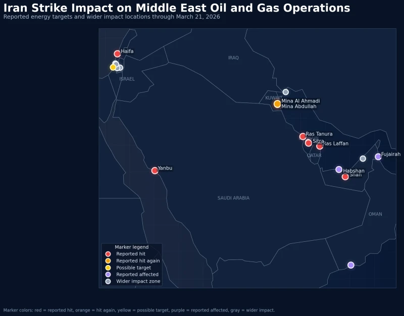
Higher priority entries are rendered with larger markers. Repeatedly reported locations stand out in orange to emphasize recurrence.
Urban impact
Part of the wider missile-impact picture beyond the main refinery map.
Urban impact
Another example of the conflict picture extending into civilian or urban-linked areas.
Urban impact
Best shown in the wider impact layer, not the core energy layer.
Urban impact
Useful in showing how the geographic footprint moves beyond industrial sites alone.
Refinery
One of the strongest entries in the timeline because it appears as a repeated reported strike location.
Refinery
A key update to the regional map because it moves Bahrain into the core energy-target layer.
Gas complex
Adds a gas processing dimension to the UAE portion of the map.
Urban impact
Represents the wider urban impact layer around Bahrain beyond the refinery zone.
Port area
Belongs in the broader logistics and port-impact layer rather than the core energy-target group.
Maritime impact
Adds a maritime disruption angle and helps explain the wider regional risk picture.
Oil refinery
A major industrial and refinery location on Israel's Mediterranean coast.
Refinery
Best treated as a secondary location because it fits more as a possible target than a core confirmed energy site.
LNG hub
One of the most strategically important locations because of its LNG role.
Refinery
Yanbu broadens the map beyond the Gulf coast and shows that the energy geography also reaches the Red Sea side.
Refinery
A key refinery location in Kuwait's concentrated energy zone.
Refinery
Supports the picture of Kuwait as a concentrated refinery exposure zone.
Gas field
Represents gas production risk and shows that the reported impact reaches beyond refineries and ports.
LPG plant
A secondary but meaningful energy-linked location that expands the southern edge of the map.
Port / terminal
Brings in the maritime and oil-loading angle, making shipping and terminal activity part of the wider energy story.
Refinery
One of the earliest major reported energy locations in the timeline.
This page is an informational visual summary based on the provided dataset.